
Computer Hardware & Software; Information Technology; Information Technology; GIS Mobile Technologies; Field Force Automation Products, Electric Power Transmission ...

Electronics & Controls & Instrumentation, Communications Cellular, Wireless; Electronics & Controls & Instrumentation, Communications Satellite; Electronics & Controls & Instrumentation, Controls; Electronics & Controls & Instrumentation, GPS Global Positioning Systems; Information Technology, GIS & Mapping; Information Technology, Inventory & Equipment Management; Information Technology, Power & Process & Plant & Utilities; Safety & Security, Alarms; Services, Fleet Management Systems, Construction Equipment ...

Electronics, Controls, Instrumentation Computer Software; Information Technology Computer Hardware & Peripherals; Information Technology Financial Management, Project Accounting, Accounting Services; Information Technology Gis, Mapping; Information Technology Internet Solutions, Networking; Information Technology Inventory, Equipment Management; Information Technology Management Consulting, Asphalt Equipment, Heavy Construction ...

Electronics & Controls & Instrumentation, Communications Cellular, Wireless; Electronics & Controls & Instrumentation, Communications Satellite; Electronics & Controls & Instrumentation, GPS Global Positioning Systems; Information Technology, GIS & Mapping; Information Technology, Inventory & Equipment Management; Safety & Security, Alarms; Safety & Security, Anti Theft & Security Systems; Services, Computer Software; Services, Fleet Management Systems; Services, Telecommunications; Services, Construction Equipment ...

Accessories; Automotive; Fleet Tracking; Location Based Services; Location Technology GPS GIS Telemetry Telematics; M2M Machine to Machine; Transportation Applications, Wireless Accessories, GPS Accessories ...

4G LTE; Fleet Tracking; Government Application; Location Technology GPS GIS Telemetry Telematics; M2M Machine to Machine; Monitoring Security Equipment; Tower and Cell Site Equipment; Transportation Applications; Utility Applications; Wireless Carrier, Wireless Accessories, GPS Accessories ...
4G LTE; Data Terminals Rugged Computers; Fleet Tracking; Internet Service Provider (ISP or WISP); Location Technology GPS GIS Telemetry Telematics; LTE WIMAX Devices; M2M Machine to Machine; Packet Data Equipment; Routers; Wireless Modules, Wireless Accessories, GPS Accessories ...
Customer Technology; Customer Information Systems; GIS Mobile Technologies; Geographic Information Systems; Metering; Prepayment Metering Systems, Electric Power Transmission ...

Geo Information Systems for Municipal Administration (Software and Solutions); Software and Solutions for Cemetery Offices; Software and Solutions for Municipal Establishments, Municipal Public Utility Undertakings; Elfried Mobile; Elfried Gis; Jpax; Prosiris; Elfried, Digital Technology ...

We have 20 Years Experience on the Field of Geoinformatics. We have Developed Different Geographical Information Applications (Gis) that Capable of Collecting, Visualizing Map Data and Integrating it with other Widely Used Mobil Applications; Based on our Unique Panoramic 3D Survey Technology of Forte Geometer600 we can do the Data Collection work about 10 (Some Cases 50) Times more Efficiently, Because you Just need to go Around the are a with the Geometer600 Fixed/Mounted to a Backpack (Or any, Digital Technology, Outdoor Packs ...
Sky Watch offer ruggedized Unmanned Arial Vehicle (UAV) technology for professional users. Our quadcopter and fixed wing multi purpose UAV platforms are configured according to customers’ requirements. Our applications range from advanced sensor piloting features, GIS and camera technologies ...

Crafts and Health Care, Yoni Eggs, Smoking Pipe, Jade Mat, Healing Stone, Hairpin, Bead, Ring, Decoration, Bracelet and Bangle, Pendant, Health Care, Surveying Instrument, Gnss (Rtk), Total Station, Handheld GPS (Gis), Level, Theodolite, Laser Rangefinders, Laser Levels, Night Vision, Ranging Telescope, Surveying Instruments, Surveying Accessories, Geological Equipment, Geophysical Exploration Equipment, Element Analyzer, Hunting Gear ...

Rdo, Rdo Integrated Controls, Gis Mapping, GPS Mapping, Surveying, Agriculture Technology, Construction, Mining, Drone Technology, Drone, Drones, Drones for Sale, Sensefly; Rdo Integrated Controls Partners With Clients To Provide Cutting Edge Technologies and Drones for the Construction, Landfill and Mining Industries; Home Rdo Integrated Controls, Mining Industry ...

Visualization Software; Consulting Services; Image Processing; Mapping Tools; 3D Mapping Software & Tools; Gis Software; Aerial Imaging; Information Technology Products; Geographic Information Systems; Location Based Services ...
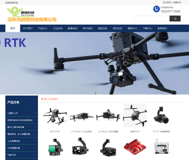
Plug, Uav Drone, Survey Hot Selling, Special Promotion Survey, Pjk Land Survey, Pjk Total Station, Pjk Theodolite, Pjk Level, Pjk Planimeter, Pjk Rtk Gps, Pjk Gis Gps, Pjk Handheld Gps, Laser Range Finder, Pjk Rebound Tester, Pjk Measure Wheel, Long Steel Measuring Tape, Pjk Measuring Rope, Pjk Prism, Pjk Tripod, Indium Ruler / Tape, Aluminium Prism Poles, Total Station, Pjk, Ruide, Trimble, Sokkia, Topcon, Stonex, Gowin, Kolida, Foif ...
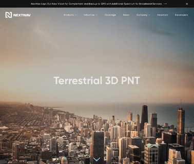
Specialty Technologies; Location Technologies: AVL & GPS & GIS; Nextnav Deployed a Revolutionary Positioning Technology Allowing Mobile Devices to Reliably Determine their Location in Indoor and Urban Environments Where GPS Doesn’T Reach. Nextnav's Technology Combines Accurate Horizontal Positioning with Floor Level Height Precision. Using a Managed Network with Carrier Grade Dependability and Metropolitan Wide Coverage, Providing Positioning Services for Precise Location Accuracy, Wireless Communications ...