

Electronics & Controls & Instrumentation, Communications Cellular, Wireless; Electronics & Controls & Instrumentation, Communications Satellite; Electronics & Controls & Instrumentation, Controls; Electronics & Controls & Instrumentation, GPS Global Positioning Systems; Information Technology, GIS & Mapping; Information Technology, Inventory & Equipment Management; Information Technology, Power & Process & Plant & Utilities; Safety & Security, Alarms; Services, Fleet Management Systems, Construction Equipment ...

Applanix, a wholly owned subsidiary of Trimble, builds, delivers, and supports products and solutions designed specifically for the unmanned aerial survey industry. Our DG technology works with UAV mapping sensors – including cameras, LiDAR, and hyperspectral sensors – to perform highly efficient mapping and surveying from a UAV. applanix ...

Electronics & Controls & Instrumentation, Communications Cellular, Wireless; Electronics & Controls & Instrumentation, Communications Satellite; Electronics & Controls & Instrumentation, GPS Global Positioning Systems; Information Technology, GIS & Mapping; Information Technology, Inventory & Equipment Management; Safety & Security, Alarms; Safety & Security, Anti Theft & Security Systems; Services, Computer Software; Services, Fleet Management Systems; Services, Telecommunications; Services, Construction Equipment ...
Engineering Services; Information Technology Products; Visualization Software; Mapping Tools; Cloud Computing; Geographic Information Systems; Integration Services; Training & Simulation; Command, Control, Communications & Computers; Aerial Imaging; Image Processing ...

Electronics, Controls, Instrumentation Computer Software; Information Technology Computer Hardware & Peripherals; Information Technology Financial Management, Project Accounting, Accounting Services; Information Technology Gis, Mapping; Information Technology Internet Solutions, Networking; Information Technology Inventory, Equipment Management; Information Technology Management Consulting, Asphalt Equipment, Heavy Construction ...
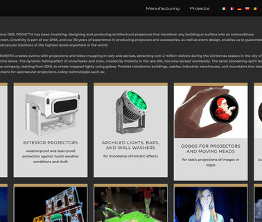
Stage Projectors and Projector Devices, Lighting Technology, Spotlights and Projectors, Projectors and Colour Changers, Lighting Technology, Spotlights and Projectors, Projector, Projections, 3D Mapping, Virtual Hostess, Interactive System, PROJECTOR IMPRESSIVE 2000W, GOBOS, INTERACTIVE SYSTEM, VIRTUAL HOSTESS, 3D MAPPING PROJECTION, Professional Lights, Commercial Sound Equipment, Office Electronics, Presentation Equipment ...
Augmented Reality & Virtual Reality; Sensors, 3D Edge Mapping; Automotive & Vehicle Technology, Virtual Reality ...

Visualization Software; Commercial Satellite Imaging; Image Processing; Mapping Tools; Aerial Imaging; Information Technology Products; Geographic Information Systems; Location Based Services ...

Cloud Computing; Geographic Information Systems; Mapping Tools; Aerial Imaging; Image Processing; Commercial Satellite Imaging; Information Technology Products ...

Rdo, Rdo Integrated Controls, Gis Mapping, GPS Mapping, Surveying, Agriculture Technology, Construction, Mining, Drone Technology, Drone, Drones, Drones for Sale, Sensefly; Rdo Integrated Controls Partners With Clients To Provide Cutting Edge Technologies and Drones for the Construction, Landfill and Mining Industries; Home Rdo Integrated Controls, Mining Industry ...
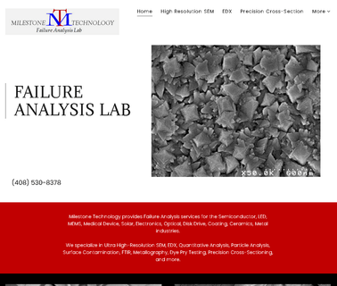
Failure Analysis Lab, Cross Section, Edx, Particle Analysis, Coatings, Ultra High Resolution Sem, Edx Analysis, Tsvs, Vias, Bumps, Wafer Contamination, Cross Section, Printed Circuit Boards, Ftir Analysis, Failure Analysis, Bga Inspection; Precision Cross Sectionand Failure Analysis Lab. SEM, EDX, Mapping, Quantitative Analysis, Cross Section Services, Semiconductor Industry ...
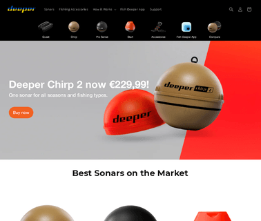
Deeper pioneered smart technology in angling with the first ever castable sonar. Since then, we have developed a range of products with features including Onshore GPS mapping and ice fishing. Now we are proud to announce a new addition to the Deeper family – the Deeper START our lightest ever model, ideal for shore anglers who just want to find the fish, Fishing Tackle ...
Mapping Tools; Geographic Information Systems; Integration Services; Information Technology Products & Services ...
ADA Compliant Products, Automated Vehicle Monitoring, Communications Equipment, Intelligent Transport Systems Technology, Passenger Information Systems, Signage and Displays, Public Trasportation, Public Transportation ...
Visualization Software; Consulting Services; Image Processing; Mapping Tools; 3D Mapping Software & Tools; Gis Software; Aerial Imaging; Information Technology Products; Geographic Information Systems; Location Based Services ...
Aerial Imaging; Integration Services; Global Positioning Hardware & Software; Mapping Tools; Geographic Information Systems; Information Technology Products & Services; Weather Services; Computer Software Services & Consultants; GPS Services; Flight Planning Services ...